Projects
Here you’ll find a list of the projects from Wake Forest’s IRSC Lab.
Current Projects
Change Detection
Monitoring change detection of the land surface is one of the critical concepts in the mean of natural resource management, deforestation, and conservation. One of the most causes of land degradation, deforestation, and water pollution is artisanal and small-scale mining (ASM) which is basically related to water bodies. To monitor the water bodies that are potential ASM ponds and detect the changes satellite imagery is commonly used. For fine-scale change detection, satellite images can be challenging because of atmospheric conditions on spectral data and representing individual objects with connecting pixels.
In this project, we investigate the change detection in the context of a current conservation challenge, artisanal-scale gold mining (ASGM) performance of two machine learning approaches (supervised and semi-supervised learning) on Sentinel-2 images. We obtained Sentinel-2 imagery and created an open-source labeled (binary and multiclass: ‘increase, decrease, water existence/absence’) land-cover change dataset for the Madre de Dios (MDD) region in Peru, a hotspot of ASGM activity, as well as active ASGM areas in other countries (Venezuela, Indonesia, and Myanmar). As supervised learning, we used E-ReCNN model and for semi-supervised learning, we used the SVM-STV approach with histogram matching preprocessing steps on multiple channels and additional La*b* color space improved performance and reduce the influence of atmospheric effects.
Autonomous Navigation in Unknown Environments
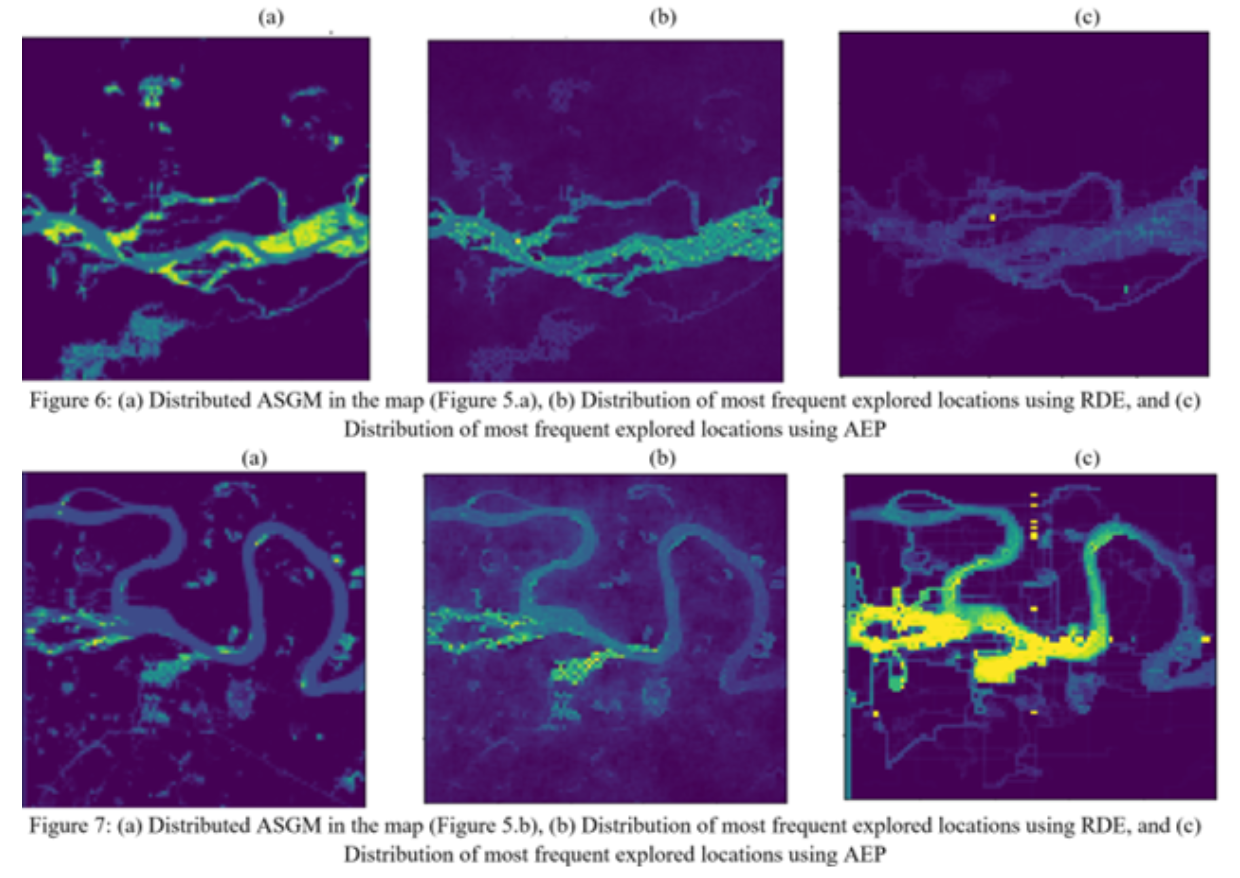
The ability to perform autonomous exploration is essential for unmanned aerial vehicles (UAV) operating in unknown environments where it is difficult to describe the environment beforehand. Algorithms for autonomous exploration often focus on optimizing time and full coverage in a greedy fashion. These algorithms can collect irrelevant data and waste time navigating areas with no important information. In this research project, we aim to improve the efficiency of exploration by maximizing the probability of detecting valuable information. We explore different optimization theories to resolve this hard problem including robustness theory of Probabilistic Metric Temporal Logic (P-MTL), ergodicity theory, and deep reinforcement learning. We target in this project several environmental and conservation navigation problems such as detecting areas occupied by illegal Artisanal Small-scale Gold Mining (ASGM) activities in Amazonian rainforest. Our preliminary results from the robustness of P-MTL show that our approach outperforms a greedy exploration approach from the literature by 38% in terms of ASGM coverage.
Image Segmentation
Image segmentation is an extremely important area of research in computer vision. For our applications, it allows us to scan over large regions in order to quickly understand the composition of there areas. Our lab is applying several recent image segmentation techniques that have been developed in other fields and adapting them to our problems with satellite imagery.
Object Detection
Basic description of project Eye-catching figures from project Link to full project page Link to repository Researchers involved
Previous Projects
Add previous projects here